Mountains Of Travel Photos
Home | Overall References | Contact 

Mount Everest North and Southwest faces burn red at sunset from Gokyo Ri.

Mount Everest North and Southwest faces burn red at sunset from Gokyo Ri.


Everest, Lhotse and Nuptse From Kala Pattar

Everest, Lhotse and Nuptse From Kala Pattar


Kangchenjunga main summit close up from Pangpema

Kangchenjunga main summit close up from Pangpema


The view of the Lhotse West Face, South Col, and the Geneva Spur from Knobby View north of Gokyo are the best in the Khumbu for a trekker.

Lhotse West Face, South Col, Geneva Spur from Knobby View north of Gokyo


Makalu West Face, Makalu West Pillar, and Makalu Southwest Face close up from the West Col (6143m). The East Col is at the lower right of centre of the photo to the left of the snow.

Makalu West Face, West Pillar, Southwest Face and East Col from West Col.


The sun slowly descends the south face of Cho Oyu (8201m), the sixth highest mountain in the world, at sunrise from Gokyo, turning the colour of the face from a golden yellow to extremely bright white within a few minutes.

The sun slowly descends Cho Oyu south face at sunrise from Gokyo.


The South and North Faces of Dhaulagiri blazed at sunrise from the camp just below the Mesokanto La.

The South and North Faces of Dhaulagiri blazed at sunrise from the Mesokanto La.


Manaslu southwest face sunrise from Syala

Manaslu southwest face sunrise from Syala


Annapurna Main (8091m), Central (8051m) and East (8026m) summits dominate the view at sunrise from Annapurna Sanctuary Base Camp.

Annapurna Main, Central and East summits from Annapurna Sanctuary. (click to enlarge)


Shishapangma, the 14th highest mountain in the world at 8012m, shines in the early morning sun from Kathmandu’s Mountain flight. The steep and treacherous southwest face is in shadow on the left. The north face is just visible in the sun on the right. On the far right the pointy rocky peak is Phola Gangchen (7716m), first climbed in 1981, and to its left is Shishapangma’s East face.

Shishapangma shines in the early morning sun from Kathmandu’s Mountain flight.


Gauri Shankar at sunrise from Suri Dhoban

Gauri Shankar at sunrise from Suri Dhoban


Close up of climbing route to Mera Peak on left, Mera Peak Central Summit (6461m), the rock sheltering Mera High Camp (5770m), and Mera Peak North Summit (6476m).

Close up of climbing route to Mera Peak Central and Mera Peak North Summits


The foothills suddenly step aside and give the pilgrim the full view of Kailas in all its grandeur. The view is absolutely overwhelming, and according to the scriptures, it is on this spot that those who are initiated into the rituals and meditations of the respective Tantras should perform their devotional practices on the great Mandala of Supreme Bliss. – Lama Anagarika Govinda: The Way of the White Clouds.

Mount Kailash North Face and the Kangjam Glacier


As we drove to Tambopaxi, the clouds slowly lifted and Cotopaxi revealed itself just before sunset. Located about 75km south of Quito, Cotopaxi (5897m) is the second highest mountain in Ecuador, after Chimborazo. Cotopaxi has an almost symmetrical cone that rises from a highland plain of about 3800m, with a width at its base of about 23km. It has one of the few equatorial glaciers in the world, starting at 5000m.

Cotopaxi (5897m), located about 75km south of Quito, is the second highest mountain in Ecuador, after Chimborazo. (click to enlarge)


Everest North Face and Rongbuk Monastery

Everest North Face and Rongbuk Monastery


The snow clad east faces of Lhotse and Everest from the Kharta Valley in Tibet.

The snow clad east faces of Lhotse and Everest from the Kharta Valley in Tibet.


Kangchenjunga main, central, and south summits; Talung, Kabru, and Ratong.

Kangchenjunga main, central, and south summits; Talung, Kabru, and Ratong.


Nuptse, Everest Southwest and Southeast faces, Lhotse, Lhotse Middle and Lhotse Shar close up from Mera High Camp (5770m) at sunset.

Nuptse, Everest, Lhotse, Lhotse Middle and Shar from Mera High Camp at sunset.


The Makalu West Face changes from white to yellow to orange to a soft red in the last rays of the sun from Gokyo Ri.

Makalu West Face burns to a soft red in the last rays of the sun from Gokyo Ri.


The long ridge between Cho Oyu (8201m) and Gyachung Kang (7952m) dominates the view north from the fourth Gokyo Lake north of Gokyo.

The long ridge between Cho Oyu and Gyachung Kang (7952m) from the fourth Gokyo Lake.


I had a great view of sunrise on Dhaulagiri from the dining room window at the New Dhaulagiri Hotel in Chitre (2420m). This view is basically the same as that from the famous Poon Hill.

Sunrise on Dhaulagiri from Chitre (2420m), similar to the famous Poon Hill.


Manaslu summit plateau with the East Pinnacle on the left and the summit to the right from Bimtang

Manaslu summit plateau with East Pinnacle on left and summit on right


After crossing the Thulo Bugin, we finally crested the ridge of the Miristi Khola. I could finally see the Annapurna north massif from floor to ceiling - man, it's huge. Clouds and mist covered it for the most part, but the ridge from Annapurna Northwest Face to Fang peaked out once in a while for me.

Annapurna Northwest Face and ridge to Fang (click to enlarge)


Here’s a closer view of the 14th highest mountain in the world, Shishapangma, as it poked briefly out of the monsoon clouds.

Shishapangma North Face from Chinese Base Camp


Kang Nachugo east face at sunrise from the Trakarding Glacier

Menlungtse (Melungtse) From Mountain Flight 1997


But what dominates the view from the Mera La (5415m) is, of course, Mera Peak with the trail to Mera High Camp (5770m) snaking up the glacier towards the rock on the left. The climbing route then goes to the right above the long snow ridge in shadow. Mera Peak Central Summit (6461m) is in the middle of the two large snow ridges, and Mera Peak North Summit (6476m) is on top of the right snow ridge.

Route from Mera La to Mera Peak Central (6461m) and North (6476m) Summits


A row of mani rocks shine in one of the brief sunny breaks next to Seralung Gompa on the shores of Lake Manasarovar.

Lake Manasarovar with a row of mani rocks next to Seralung Gompa


Chimborazo, located 150km south-southwest of Quito, is the highest mountain in Ecuador at 6310m. From left to right are four of the five summits of Chimborazo - Ventimilla (6267m), Whymper (6310m, Main), Politecnico (5820m, Central) and Nicolas Martinez (5570m, Eastern).

Chimborazo is the highest mountain in Ecuador at 6310m.


Kathmandu Durbar Square is a complex of beautiful Hindu temples and shrines built in the 16th and 17th centuries in pagoda style embellished with intricately carved exteriors. Trailokya Mohan Narayan, Maju Deval and Narayan Temples shine in the early morning sun. Trailokya Mohan Narayan Temple (1690) stands on a five-stage plinth with three roofs and is dedicated to Vishnu.

Kathmandu Durbar Square: Trailokya Mohan Narayan, Maju Deval and Narayan Temples.


The first sight on reaching the top of the stairs is the Swayambhunath stupa flanked by two snow lions, with a giant gilded vajra above a mandala worked in a drum-shaped base. The earliest record of this stupa's existence dates from a 5C stone inscription; however, scholars and archaeologists believe that there was probably a shrine here as far back as 2,000 years ago.

Swayambhunath Stupa entrance at the top of the pilgrim steps in Kathmandu.


The Tiji Festival in Lo Manthang is about a deity named Dorje Jono who battles his demon father to save the Kingdom of Mustang from destruction. The demon father wreaked havoc on Mustang by bringing a shortage of water and causing many resulting disasters from famine to animal loss. Dorje Jono and his retinue perform a series of 52 magical dances to repel the resident evil. Dorje Jono eventually beats the demon and banishes him from the land. The festival takes place in the main town square in Lo Manthang.

The Tiji Festival takes place in the Lo Manthang main square in Upper Mustang


The Potala Palace, perched high above Lhasa on the Marpori (red mountain)
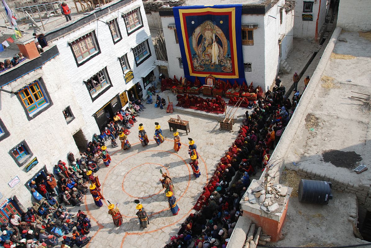
, is a place of spiritual pilgrimage and a mammoth tribute to Tibetan architectural skills. The name Potala derives from the Sanskrit ‘Potalaa’, the abode of the Bodhisattva Avalokiteshvara. Unlike most Tibetan monasteries, the Red Guards did not sack the Potala during the Cultural Revolution, and, as a result, all the chapels and their artifacts are remarkably well preserved.

The Potala Palace, the winter home of the Dalai Lama, is perched high above Lhasa.


Commissioned by a Gyantse prince in 1270, the Kumbum chorten was built in the style of a 108-sided mandala by craftsman from the Kathmandu Valley, and houses many excellent unique frescoes of Newari influence, a painting style originating in Nepal's Kathmandu Valley. It rises in eight stages to over 52m and has lots of images (Kumbum means '100,000 images') and 70 chapels. It is topped in typical Nepalese Buddhist style with the all-seeing eyes, the spire, umbrella and the pinnacle. The first five floors are four-sided, while the upper floors are circular, forming a huge three-dimensional mandala.

The Kumbum chorten in Gyantse, Tibet, rises in eight stages to over 52m.


The Tibetan Wheel of Life is perhaps the most common of all pictures in Buddhist art and is seen on the walls of monasteries and painted scrolls all over Tibet, Nepal and other Himalayan countries. The 23 parts of the painting represent in visual terms some of the more fundamental teachings in Buddhism such as the 12 steps of dependent origination, the karmic laws of cause and effect, and the three kleshas of ignorance, greed and hatred.

The Tibetan Wheel of Life is perhaps the most common of all pictures in Buddhist art.


The Serkhang chorten in Tholing in the old Guge Kingdom in Western Tibet is bathed in an evening rainbow.

Serkhang chorten in Tholing (Tibet Guge Kingdom) is bathed in an evening rainbow.


The roof of the Hotel NH Parque Central in Havana Centro had spectacular sunset views of the Capitolio, the Gran Teatro de la Habana, Hotel Inglaterra, and Hotel Telgrafo in 2008.

Havana: Capitolio, Gran Teatro de la Habana, Hotel Inglaterra, and Hotel Telgrafo.


Dubai Creek, the historic focal point of life in the city, is a natural seawater inlet that cuts through the city's centre and separates Deira from Bur Dubai. The creek is alive with trade and tradition, the loading and unloading of trade ships that still travel ancient routes, and the beautiful promenades that line both sides of the water. In this view from near the mouth, the Grand Mosque dominates the Bur Dubai skyline, while the buildings of Deira are behind, including the Etisalat building with the golf ball on top, the Dubai Creek Tower, the curved National Bank of Dubai, and finally the triangular Dubai Chamber of Commerce building.

Bur Dubai: Grand Mosque, Etisalat, Dubai Creek Tower, National Bank of Dubai, Dubai Chamber of Commerce.


Here is a view of Quito taken from north of the airport looking south. Quito is the capital of Ecuador with a population of about two million people, situated between two mountain ranges at an altitude of 2800m.

Quito (2800m), the capital of Ecuador, from our airplane north of the airport looking south.


Buckingham Palace is the official London residence of The Queen and is one of the most famous and easily recognizable façades of any building in the world.

Buckingham Palace is the official London, England residence of The Queen.


The blue-footed booby is one of the highlights of our trip to the Galapagos. We could get so close it was amazing.

Galapagos Islands: Blue-footed booby is one of the many highlights.


Just 10 minutes walk from the Victoria Peak Tram station along Lugard road is this spectacular view of the Central District, the harbour, and Kowloon. It is especially breath-taking at night.

Victoria Peak view of Hong Kong with the Central District, the harbour, and Kowloon.


On the river Hvita, Gullfoss is Iceland’s most famous waterfall, tumbling in a pair of broad cataracts, the first 10m in full view, then the river bends a sharp 90 degrees and falls a further 20m into the gorge’s spray-filled shadow.

Gullfoss is Iceland’s most famous waterfall.


Mutrah is especially beautiful at night with the lights reflecting off the water and the white facades of the old merchants' houses that front the promenade.

Muscat: Mutrah is especially beautiful at night.


From the Swissotel Equinox restaurant on the 70th floor, I took photos of the downtown towers, the Singapore River, and the Padong as the lights came on.

Singapore downtown towers, the Singapore River, and the Padong.


Just after entering the Wat Phra Kaeo we saw the golden Phra Siratana Chedi, a 19th-century Sri Lankan-style stupa supposedly housing ashes of the Buddha.

Just after entering the Wat Phra Kaeo we saw the golden Phra Siratana Chedi.


New York City Top Of The Rock Just After Sunset South Midtown To Empire State Building To Financial District, Bank of America Tower

Empire State Building To Financial District From Top Of The Rock (click to enlarge)


Kathmandu’s 36m-high Boudhanath Stupa is the largest stupa in Nepal, and one of the largest in the world. It is a religious centre for Nepal's considerable population of Tibetans. It supposedly dates from the fifth century. With three square tiers surrounding the central circle of the dome, Boudhanath is built in the form of a mandala, a symbol of the universe that is often used in Buddhist meditations.

The Boudhanath Stupa in Kathmandu is a religious centre for Nepal's Tibetans.


Kathmandu’s Pashupatinath temple complex is the holiest Hindu site outside India. Pashupati is one of the many names of Shiva, the most revered god in the Hindu pantheon, this one meaning the Lord of the Animals. Supposedly Shiva needed a holiday from Mount Kailash and chose the Kathmandu valley. Non-Hindus are not allowed to enter the temple. Below the Pashupatinath temple runs the Bagmati River, a holy river that eventually joins the Ganges. Pilgrims throw the holy water onto themselves, while a few hearty Hindus bathe fully.

The Pashupatinath temple in Kathmandu is the holiest Hindu site outside India.


The trail descends from Lo Manthang (3910m) to cross a stream before ascending to the Lo La (3950m) with our last view of the walled city of Lo Manthang. The trail then traverses the Tholung Valley before reaching a ridge (3580m) looking over the village of Tsarang (3560m). The trail descends to cross the Tsarang Chu, and climbs 125m to Tsarang, the second largest village in Mustang. I walked across the village to see the entrance chorten nicely framing the village and the Tsarang gompa and old dzong.

Tsarang chorten in Upper Mustang frames the Tsarang gompa and old dzong.


The Chapel of Jowo Shakyamuni is the most important shrine in Tibet, housing a 1.5m sitting image of Shakyamuni at the age of 12. It is supposedly one of only three made during his lifetime. It was a gift from the Chinese Princess Wencheng to her husband King Songtsen Gampo. The Jowo sits on a majestic massive three-tiered stone platform. Two silver-plated dragons presented by the Chinese emperor entwine the ornate pillars that support an intricate double canopy over the Jowo. An ornate crown of coral, turquoise, diamonds, rubies, and other precious gems, sits on the Jowo’s head. Although there’s no photography allowed, here’s a photo from my 1993 trip. Note the photo of the current Dalai Lama, allowed in 1993 in a period of religious tolerance.

Jowo Shakyamuni statue in Lhasa Jokhang temple is the most important in Tibet.


The most impressive Tashilhunpo sight is the Maitreya Chapel, a tall red building with a gold roof at the complex’s northwestern corner, built in 1914 by the ninth Panchen Lama. It houses a 26.2m image of Maitreya, the Future Buddha, whose ears are 2.6m long and each finger 1.2m. The statue contains 279kg of gold and 150,000kg of copper and brass molded on a wooden frame.

The Tashilhunpo Maitreya Chapel in Tibet houses a 26.2m image of Maitreya.


We watched the devout pilgrims prostrate themselves at the Jokhang Temple’s entrance doors. Their hands are protected by large mittens or small block of wood fixed to the waist by a lace. People kneel, their hands reach the ground and they start sliding until the whole body extends on the ground too. Standing up they then repeat the action again and again.

Pilgrims prostrate themselves at the Jokhang Temple in Lhasa.


Immediately to the right of the door of the White Temple at Tsaparang in the old Guge Kingdom in Western Tibet is a 5m-high guardian figure, blue Vajrapani (Tib. Chana Dorje). The significantly elongated torsos, a typical Guge trademark, have been broken open, exposing the straw. This has since been closed with what looks like white plaster. To the left of Vajrapani is an empty pedestal that used to contain a statue of Tara. Photo - Weyer/Aschoff: Tsaparang, Tibets Grosses Geheimnis.

Blue Vajrapani statue in the White Temple at Tsaparang (Tibet Guge Kingdom)


The Palacio Brunet, now the Museo Romantico, is a two-storey mansion in warm yellow stucco on Plaza Mayor in Trinidad de Cuba. The ground floor of the Palacio Brunet was built in 1740, and the upstairs was built in 1808. It was once owned by a sugar baron, but was converted into a museum in 1974. On the left with the yellow and green bell-tower is the former convent of San Francisco de Asís, now the Museo Nacional de la Lucha Contra Bandidos.

Trinidad de Cuba: Palacio Brunet (Museo Romantico) on Plaza Mayor


After dark the translucent fiberglass wall of the Burj Al Arab in Dubai serves as a projection screen for a nightly light show. Here is a dusk view from the beach of the Jumeirah Beach Hotel.

Burj Al Arab in Dubai dusk view from the beach of the Jumeirah Beach Hotel


We had dinner at Cafe Mosaico in an old house high up on a hill overlooking Old Quito. The view from Cafe Mosaico is excellent. Here is a view of Old Quito and El Panecillo just after dusk as the lights came on.

Old Quito and El Panecillo just after dusk from the Cafe Mosaico.


The Tower Bridge was opened in 1894 and measures 120m between the two towers, which house the machinery for raising the bascules in 90 seconds. The upper walkway is open to visitors.

The Tower Bridge in London, England measures 120m between the two towers.


The panoramic view from the summit of Bartolome is probably the most photographed landscape in the islands. You can see the twin bays, the Pinnacle Rock, the moonlike landscape and a view of Santiago Island close by and its famous Sullivan bay.

The panoramic view of the twin bays and Pinnacle Rock from the summit of Bartolome.


The green-and-white Star Ferries that have been carrying passengers back and forth between Kowloon and Hong Kong Island since 1898.

Star Ferries carry passengers between Kowloon and Hong Kong Island.


You can take a boat trip on the lagoon and float among the icebergs. Supposedly the water is so cold that if you fell overboard you could expect to survive at most 2 minutes.

You can take a boat trip on the Jokulsarlon lagoon in Iceland


The Sultan Qaboos Grand Mosque is the third largest in the world, built between 1995 and 2001 from 300,000 tons of Indian sandstone. The complex is 1000m long and 885m wide. The most visible part of a mosque is the minaret, the tower from which the call to prayer is broadcast five times a day. There are four 45.5m minarets on the corners and a big central one of 91.5m, the five minarets symbolizing the five pillars of Islam.

The Sultan Qaboos Grand Mosque in Muscat is the third largest in the world.


The regal Raffles Hotel opened in 1887 as a 10-room bungalow, and exactly one hundred years later in 1987, it was declared a national monument. The hotel has seen its fair share of kings and queens, presidents and movie stars. We couldn’t afford to stay there are, but we did go in to gaze at its elegance and style.

The regal Raffles Hotel in Singapore opened in 1887 as a 10-room bungalow.


Also known as the Temple of the Reclining Buddha, Wat Po was built by Rama I in the 16C and is the oldest and largest Buddhist temple in Bangkok. The enormous Reclining Buddha is 46m long and 15m high, with each foot 3m high and 5m long. The statue is brick, covered with layers of plaster, and gold leaf. The most striking part of the statue is its soles, which are decorated with 108 auspicious patterns inlaid with mother-of-pearl.

The enormous Reclining Buddha in Wat Po in Bangkok, Thailand.


View South To 1 Times Square From Top Of Red Stairs in New York City Times Square At Night

Times Square At Night From Top Of Red Stairs in New York City (click to enlarge)

Updated: July 2010. Click on an image to see the FULL size with a caption.

Mountains Of Travel Photos


Jerome Ryan on Chukung Ri (5550m) near Mount Everest in 1997

Jerome Ryan on Chukung Ri lower summit (5550m) near Mount Everest in 1997


Jerome Ryan, Peter Ryan, Charlotte Ryan on Kailash Dolma La (5636m) in 2006

Jerome Ryan, Peter Ryan, Charlotte Ryan on Kailash Dolma La (5636m) in 2006


Mustang Future King Jigme S. P. Bista And Jerome Ryan At Royal Palace In Lo Manthang in 2008

Mustang Future King Jigme S. P. Bista And Jerome Ryan At Royal Palace In Lo Manthang in 2008


Charlotte Ryan, Dangles, Peter Ryan, and Jerome Ryan pose on the roof of the Jokhang Temple with the Potala Palace behind.

Charlotte Ryan, Dangles, Peter Ryan, and Jerome Ryan pose on the roof of the Jokhang Temple with the Potala Palace behind.

My name is Jerome Ryan and I am an amateur photographer who loves to trek in the mountains; or as I like to say, "I climb to the bottom of the mountains". I also like to travel around the world.

For the first 17 years of my life, I only traveled less than 100km from my hometown. I started dreaming of what was over the next hill, and that fascination is still with me today. Give me a hill, and I have to climb to the top to see what's on the other side.

My wife Charlotte Ryan and my son Peter Ryan travel with me a lot of the time, but usually not on the treks. They did trek over the Dolma La (5636m) on the Mount Kailash kora in 2006.

Although I had traveled in the mountains over the years, my keen interest started in 1996 when I read the September 1996 Outside magazine "The Story On Everest" article by Jon Krakauer. Over a few months period, I kept going back to the article, especially admiring the beautiful colour photographs, like the Balcony and the Hillary Step and summit ridge. I was hooked.

Trekking in the Nepal mountains and Tibet over the years has led me to an appreciation of their local culture, especially Tibetan Buddhism. From my travels through Europe, I've grown to love art and sculpture.

Photos may be used freely for personal non-commercial use. Have fun travelling on my web pages.


My New Youtube Videos - New York City Empire State Building and View From Top Of The Rock, View From Mera Peak High Camp, Landing And Taking Off From Lukla, Nepal


News

I am still working on my plans for October 2010 - probably going to Tibet to trek to Shishapangma, Cho Oyu, and Everest Advanced Base Camps, and possibly attempt to climb Lhakpa Ri (7045m), supposedly the easiest 7000m peak.


Dalai Lama Meets President Obama At The White House February 18 2010

Bizarro Buddhism Comic - Free From Desire

The Dalai Lama had a 70-minute meeting with U.S. President Barack Obama at the White House on February 18, 2010. A CNN/Opinion Research Corp poll says that nearly three-quarters of all Americans think Tibet should be an independent country.

Here is another funny, yet relevant, Buddhist comic from Bizarro


Site Updates

May 2010 - I finally finished all of my Mount Everest photos from Lukla to Namche Bazaar, Khumjung, Tengboche, Dingboche, Lobuche, Gorak Shep, Kala Pattar and Everest Base Camp.

April 2010 - Added New York City photos, including Landing At Laguardia, Times Square, Empire State Building, Rockefeller Center And Top Of 30 Rock, Flatiron Building, Chrysler Building, Fifth Avenue, Central Park, the Museum Of Modern Art (MOMA), and the huge Metropolitan Museum Of Art.

February 2010 - Added Lhotse photos. These Lhotse photos are pulled from the other sections on Everest, Makalu and Mera Peak.

February 2010 - Added photos to Everest from my 2008 crossing of Cho La and Kongma La. Kongma La has sensational views of Lhotse West Face and Lhotse South Face.

January 2010 - Added Mera Peak. Photos from my October 2009 trek down the Hongu Valley and climbing Mera Peak with views of five of the six highest mountains in the world - Cho Oyu (#6), Everest (#1), Lhotse (#4), Makalu (#5), and Kangchenjunga (#3). Magnificent! From Mera Peak, I trekked down the Hinku Valley, and over the Zatrawa La to Lukla.

January 2010 - Added Makalu. Photos from my October 2009 trek to Makalu Base Camp South in Nepal, and then over the East and West Cols to the Hongu Valley. Also includes photos of Makalu North Face from my 1998 trek to the Kama Valley in Tibet, and photos from the Khumbu area of Nepal.

October 2009 - Added all photos of my 1998 drive from Kathmandu to Everest North Face and the trek from Kharta to the rarely visited Everest Kangshung East Face.

August 2009 - Added Annapurna and Dhaulagiri. Photos of the Annapurna Circuit, Annapurna Sanctuary, Annapurna North Base Camp, Jomsom to Mesokanto La, Marpha to below Dhampus Pass. Excellent views of Annapurna, Fang, Dhaulagiri, Tuckuche Peak, Nilgiri, Annapurna II, Annapurna South, and Machapuchare.

May 2009 - Added Cho Oyu. Major update to Everest. Photos of Thame, Renjo La, Khumkung to Gokyo, Gokyo, Gokyo Ri, Nameless Fangs, Scoundrel's View, and Knobby View. The sunset photos from Gokyo Ri of Cho Oyu, Everest, Lhotse, Nuptse, Makalu, Cholatse, Taweche are sensational if I do say so myself.

March 2009 - Major update to Kathmandu - new photos of Kathmandu, Boudhanath, Swayambhunath, and Pashupatinath. Added photos for Budhanikantha, Kirtipur, Chobar Gorge, and Kathmandu Mountain Flight photos of Everest, Lhotse, Makalu, and Cho Oyu.


Nepalese guide Gyan Tamang And Jerome Ryan on Larkya La Around Manaslu in 2003

We stopped for a team photo just before the West Col - from left to right: climbing Sherpa Palde, cook Pemba Rinjii, porter Pal Dorje, Jerome Ryan, guide Gyan Tamang, porter Tenzing, and cook helper Pasang.

I have used the same Nepalese guide Gyan Tamang for my treks in Nepal and travel in Tibet. You can reach Gyan Tamang at gptamang@hotmail.com.

This site is best viewed at 1280 x 1024 pixels, or else you will have to scroll to see the photos.

I use Lightbox JS freeware to popup images within a page.

I use Jalbum Photo gallery software freeware to create the photo albums.

I have also made the web pages compliant to Valid XHTML 1.0 Strict


Site Navigation

1. Click on an entry on the two navigation bars at the left. This will bring you to the main menu of each area.

2. The main menu gives a brief overview of the area, my favourite memories of the area, and another navigation bar on the left.

3. Click on that navigation bar to see the photos. If there are lots of photos, I've grouped them into chapters. I've also included references I used for my treks and trips, such as guide books, books, website extwernal links and DVDs and videos.


New Books and DVDs


Front cover: Ed Viesturs And Scott Fischer On K2 Traverse Aug 16 1992. Back Cover: Ed Viesturs On Everest Summit May 19 2009.

Charley Mace Photo Of Ed Viesturs And Scott Fischer on K2 Summit August 16, 1992 - K2: Life and Death on the World's Most Dangerous Mountain book 

Chris Klinke Photo On Aug 1, 2008 Showing Traffic Jam On The Traverse - K2: Life and Death on the World's Most Dangerous Mountain book

K2: Life and Death on the World's Most Dangerous Mountain

by Ed Viesturs, David Roberts. Published 2009. America's first mountaineer to climb the 14 8000m peaks, Viesturs describes the major events on K2 along with his personal views. Ed examines "the questions of risk, ambition, loyalty to one's teammates, self-sacrifice, and the price of glory", sharing his direct honest opinions, like: "jerk", "I just don't buy it", "why didn't he get out and do something", and "that directive strikes me as questionable at best". I myself firmly believe in Ed's approach - getting into great physical shape with a thoroughness and intensity of preparation and planning, being a clock watcher and on time, non confrontational, carrying your own weight, and being patient.

You should buy this book first and foremost for Viesturs account of his own summit of K2 in 1992, second for his opinions of the controversial 1939 U.S. expedition led by Fritz Weissner, third for his critique of the August 2008 season where 11 climbers died in a 36-hour period, and finally as a history of the main events in K2's history, including 1938 U.S. reconnaissance expedition, the 1953 U.S. expedition, the controversial first ascent by the Italians in 1954, and the terrifying 1986 season that left 12 dead. There are 8 pages of colour photos (4 from Viesturs K2 ascent in 1992), 8 pages of b/w photos, a 2-page map, and one b/w sketch..

The book starts with Ed critiquing the 2008 tragedy where 11 climbers died in a 36-hour period. He clarifies the misconception that they were all killed when pieces of the frightening large ice serac above the bottleneck fell off. He also states that the real heroes were the Sherpas, unselfishly going back up the mountain to rescue climbers. Ed critiques the dependency on fixed ropes, the lateness of leaving Camp 4 and reaching the summit, and the fact there were no wands to help people find the route.

My favourite chapter is when Ed tells the true story of what happened on his ascent of K2 with Scott Fischer and Charley Mace on August 16, 1992. I was disappointed with No Shortcuts To The Top because the stories were too short and too 'perfect'. Not in this book. Ed uses his diaries to share his innermost raw, blunt, and critical feelings and opinions, highlighting his problems with his teammates and other teams, and lack of leadership. It is tight, entertaining, tense, emotional, an epic! This chapter could have been the whole book and I would have been happy.

Ed and Scott had to put off their own attempt to rescue two climbers. Although Ed is normally risk averse, he and Scott accepted danger to try and rescue two climbers. They were caught in an avalanche, but Ed was able to self arrest and stop their fall. Ed comments on once again accepting too much risk on summit day: "As we got closer to the summit and the falling snow showed no signs of letting up, I knew I was making the greatest mistake of my climbing life. And yet I kept going. ... Scott, Charley, and I broke free of the clouds just short of the summit. We saw it shining in the sun ahead of us. At noon, we stood on top, hugging each other and gasping in the thin air. ... After only thirty minutes on top, we headed down. ... Soon we were stumbling downward in a thickening whiteout." After reaching Camp 4 at 5pm, he wrote in his diary: "We'd pushed our luck beyond the max. I hope I never do that again! No summit is worth dying for. You can always come back." When they reached Camp 4, they found Rob Hall dealing with a very sick Gary Ball suffering from cerebral edema. They now had to help Gary down in bad weather and terrible avalanche danger. They found Ed's wands in the deep snow, which saved their lives by showing them the correct route down. "I don't think I've ever been more physically or emotionally exhausted in my life after that climb and descent."

After a brief history of the 1902 attempt by Oscar Eckenstein and Aleister Crowley and the 1909 attempt by the Duke of Abruzzi with Vittorio Sella, Ed describes in straightforward detail the 1938 US reconnaissance expedition led by Charlie Houston, quoting sections from "Five Miles High". After reconnoitering the Northeast and Northwest sides, the team decided that the Abruzzi was the best choice. After setting up camps on the ridge, Bill House climbed a great slanting gash in an almost vertical rock now called House's Chimney, and Charlie Houston and Paul Petzoldt reached 7920m feet before turning back due to not enough food and equipment at the highest camp.

My second favourite chapter is when Ed's writing is once again opinionated and enlightening as he describes the controversial 1939 US expedition led by Fritz Wiessner, who had recently emigrated to the US from Germany. After the best climbers dropped out, Fritz had to lead an inexperienced and weak team. Fritz led all the way, breaking trail, and turned back at 8380m just below the easy summit snowfield when Pasang Lama wouldn't go on. After a second attempt failed because Pasang had lost his crampons, Wiessner and Pasang descended to Camp VIII, only occupied by Dudley Wolfe. On the descent the three climbers fell, but Wiessner was able to self arrest, stopping their fall. Viesturs thinks that "only Pete Schoening's 'miracle belay' in 1953 is more legendary than Wiessner's self arrest." Unknown to Wiessner, all camps below camp VIII had been stripped supposedly because they thought that the summit party had been killed. The attempt to rescue Wolfe failed, with Wolfe and three Sherpas perishing on the K2 Shoulder. Ed thinks that "any climber has to be in complete awe of Wiessner's performance on K2." and considers his logistical plan "brilliant" Viesturs calls much of the criticism in the 1992 book K2: The 1939 Tragedy by Andy Kaufman and William L. Putnam "cockeyed", especially the fact that Wiessner led from the front, leaving Wolfe at camp VII on the descent, and what he considers the racial profiling of Wiessner.

Next, Ed describes the 1953 U.S. expedition led by Charlie Houston, calling it "the high point of American mountaineering", and "The courage, devotion and team spirit of that expedition have yet to be surpassed." He quotes from "K2: The Savage Mountain" and from Dee Molenaar's never released diary. A storm hits and they have to remain at Camp VIII for seven days, with Art Gilkey developing thrombophlebitis. In very bad weather and high avalanche danger, the rest of the team attempt to lower Gilkey down the mountain. Pete Schoening performed "the most famous belay in mountaineering history" when he singlehandedly stopped the fall of six teammates with "a single axe and a grip of steel." But the rescue ended in tragedy a few minutes later when Gilkey was avalanched to his death.

The camaraderie and teamwork of the 1953 U.S. team fades into intrigue and back-stabbing on the first ascent of K2 in 1954 by Italians Lino Lacadelli and Achille Campagnoni, with Walter Bonatti becoming a very convenient villain and an ideal sacrificial goat. Walter Bonatti and Pakistani Mahdi carried oxygen bottles to Camp IX, but had to suffer a bivouac at 8100m when Campagnoni intentionally moved the camp from the planned site so Bonatti could not try for the summit. Once back home, Bonatti was silently and later publicly accused of treachery, trying to steal the summit, and using their oxygen. Ed describes it as "a feud so sordid, bitter, and long-lasting that it has few parallels in mountaineering history." Vindication came in 2004 when Lacadelli agrees with most of Bonatti's views in his book K2: The Price of Conquest.

Finally, Ed describes in straightforward detail the tragic 1986 climbing season when 13 people were killed, quoting from Kurt Diemberger's The Endless Knot and Jim Curran's K2: Triumph and Tragedy. After eight unrelated deaths, a snowstorm with excessive wind and cold temperatures hit seven climbers, keeping them tent bound at Camp 4. Julie Tullis died in her sleep. After several days, in a break in the storm, Kurt Diemberger, Dobroslawa Wolf, Alfred Imitzer, Willi Bauer, and Hannes Weiser immediately started down, leaving a delirious Al Rouse at Camp 4. Within a few hundred feet of leaving camp, Imitzer and Wieser collapsed and were left where they lay. With Bauer breaking trail, the other three kept fighting their way down. A few hours later Wolf dropped behind and did not reappear, and the team was down to two. Bauer and Diemberger staggered and stumbled their way down the mountain.


Climbing The Cesan Route With The Huge Serac And Shoulder Above - Surviving K2: Surviving Three Day in the Death Zone book cover

Gerard McDonnell, the first Irishman on the summit of K2. On the summit, K2's shadow across the valley. Gerard and Pemba on the summit with a message for the world. On the summit on August 1, 2008 at 18:39 Gerard, Pemba, Wilco and Cas. The route to the summit and back. - Surviving K2: Surviving Three Day in the Death Zone book

K2 Situation August 2, 2008 at 09:00 and 18:00 By Pemba At Camp 4 - Surviving K2: Surviving Three Day in the Death Zone book

Surviving K2: Surviving Three Day in the Death Zone

by Wilco van Rooijen. Published 2010 in English. The author describes his K2 attempts in 1995 and 2006 before telling the harrowing story of his survival during the deadly 2008 K2 season when 11 climbers died in a 36-hour period. There are 32 pages of colour photos. Wilco writes: "The difference between life and death, particularly on K2, is a thin elastic band. If you stretch it too far, it snaps. ... Those seracs are as huge as skyscrapers, cathedrals and they are teetering; no way stable. If any fragments were to collapse we wouldn't stand a chance."

Exciting, frightening, and heroic story of the author's survival on K2 in 2008 and the heroic rescues of the stranded climbers, especially by Pasang, Gerard McDonnell, and Pemba. I really liked Wilco's tight writing style in keeping to the essence of the story, and sharing his first-hand experiences and what is going on in his mind. The photos are excellent, especially the Pemba Gyalje photos of the serac and the bottleneck area, showing the locations of the various mountaineers at 09:00 and 18:00 on August 2, 2008.

ExplorersWeb gave their Best of ExplorersWeb 2008 Award to Gerard McDonnell: "The most selfless effort was made by Irish Gerard MacDonnell, who after two nights on K2's upper slopes including one in an open bivouac, resolved to alone stay and help two Korean climbers and a Nepali Sherpa, climbers he didn't know. Gerard knew well that his effort seriously put his own life at risk. His action is almost unmatched on the 8000ers. ... Gerard was called 'Jesus' by his peers. 'Hero' is a better word."

After briefly describing his ascent of the north face of the Eiger in July 1994, Wilco describes his first K2 attempt in 1995. Wilco describes in graphic detail how he got hit by a large rock above Camp 1, suffered a near fatal concussion, and had to be led down the mountain. Wilco's second K2 attempt was in 2006. He first attempted Broad Peak, but turned back between the false summit and the true summit because it was too late. He then turned to K2, climbing through the constant rock fall on the Abruzzi route. Teammate Gerald McDonnell was hit by a rock and had to flown out to a hospital in Skardu. Wilco's attempt failed below Camp 4 from bad weather.

Wilco returned in 2008 as the leader of the Norit K2 Expedition, attempting the Cesan route to the left of the normal Abruzzi route. Summit day August 1, 2008 began with Pemba Gyalje leaving Camp 4 on the Shoulder at 1:30am to help fix ropes in the Bottleneck, followed by Wilco, Gerard McDonnell, Jelle Staleman, and Cas van de Gevel at 2:30am. When Wilco reached the Bottleneck, he found that they had used fixed ropes on the easier lower portion and were now out of rope. Jelle decided to go down. Wasting valuable hours, they went down to retrieve the rope and then fixed it in the Bottleneck and Traverse. But, now there was a bottleneck of 19 people in the Bottleneck. Chris Klinke decided to go down, taking a spectacular photo showing the bottleneck of people. The first two fatalities occurred when Serbian Dren Mandic unclipped from the rope and fell to his death, and porter Jehan Baig slipped and fell trying to bring Mandic's body back to Camp 4.

"I crawl the last metres. I cannot believe it, we have made it!" Wilco van Rooijen, Gerard McDonnell, Cas van de Gevel, and Pemba reached the summit of K2 on August 1, 2008 at around 18:30. "We shout, we are happy, we are utterly exhausted. We hold each other, tears rolling down our cheeks." They leave the 'blissful feeling on the summit' and start to descend around 19:00 into "the hard reality of small ledges, slippery, black rocks, treacherous snow and immense ice masses."

Wilco, Gerard and the Italian Marco Confortola lose the route in the dark and bivouac in a snow hole. Ahead of them Norwegians Lars Naesse, Cecile Skog and her husband Rolf Bae were descending the Traverse to the Bottleneck in the dark when "a large section of ice breaks off and sweeps Rolf away. ... The rope that runs through the Bottleneck is also swept away." The climbers would now have to descend the Traverse and Bottleneck with only fragments of ropes to clip into. Lars and Cecile continue climbing down to Camp 4. Cas descended the Bottleneck in the dark, but when he reached the bottom he saw Frenchman Hugues D’Aubarede fall past him. Cas continued to camp 4 where Pemba was already melting snow.

The next morning Wilco, Gerard and Marco continue looking for the route, but when Wilco notices he was starting to go snow-blind he heads straight down as fast as he can. He stumbles onto a rope and finds the route, but finds two Koreans and Sherpa Jumic Bothe hanging upside down tangled in the ropes. A fourth Korean was already missing. Wilco doesn't have the energy to help them, and continues his descent. "What can I do? Nothing. I am at the end of my strength.. And here is a huge jumble of ropes and people. ... Life has been reduced to the essence of survival. Nothing more. ... I am hardly thinking, but acting on instinct." He loses the route again and when he reaches a very steep portion, he turns around and climbs back up to the ropes. He finally reaches the bottom of the Bottleneck, but he loses the way again in a thick mist.

Meanwhile, Gerard and Marco also come across the two Koreans and Jumic Bothe. They try, but can't untangle them from the ropes; so Marco descends. However, Gerard selflessly stays, and after six hours is able to free them, and they descend together. Gerard tragically is hit by a chunk of serac and falls to his death. Pemba climbed back up to help the barely conscious Marco just below the Bottleneck. Two of the Korean Sherpas, Pemba and Tsering, climbed back up from Camp 4 to help the Koreans descend. After reaching the summit with Marco, Pakistan Meherban Karim lost the route and apparently on August 2nd fell over the Serac. But then, another serac avalanche occurs. Tsering managed to jump out the way, as did Pemba at the Shoulder, catching Marco by the neck. However, the slide carried with it Jumic, Pasang, and the two young Koreans.

The lost Wilco has the bright idea to call his wife Heleen at home in the Netherlands. He asks her to call base camp in the Netherlands to call K2 Base Camp to call Camp 4 and have Pemba and Cas look for him. It works! Pemba calls him on the phone and tells him to descend straight, and that he and Cas will ascend, yelling to see if they can find each other. But once again Wilco veers off the route, with "blurry views and no points of recognition, I am alone in a dull, ice-cold world of snow, mist and rocks, and suffering from poor vision." He calls Heleen again to relay that he can't find Pemba, and continues his descent. "God, I feel so alone. This is the end ... Am I in heaven? Or have I checked into hell?" His eyesight starts to improve and he descends faster to about 7350m. "At this point back in Base Camp, Chris Klinke ... observes an orange speck [Wilco] moving slowly high up on the mountain to the left of the Cesan Route above camp 3." Base camp calls Pemba and Cas to descend to camp 3 and find Wilco. But night falls, and Wilco has to bivouac again, sitting near two dead climbers. "It is all weighing heavily: thirst, loneliness, the steepness, the cold, the dark. My feelings are numbed." Pemba reaches Camp 3, but Cas also has to bivouac, in fact only 300 metres from Wilco. The next morning Wilco starts to descend at first light and finds Cas. "We fall into each other's arms and cry." Pemba arrives and then they descend the mountain and the next day fly out by helicopter.


Steve House On Nuptse South Face 2002 - Beyond The Mountain book cover

Vince Anderson Climbing Nanga Parbat Rupal Face September 2005 - Beyond The Mountain book

Steve House On Nanga Parbat Summit September 6 2005 after climbing a new route on the Rupal Face with Vince Anderson - Beyond The Mountain book

Beyond The Mountain

by Steve House. Published 2009. Winner of the 2009 Boardman Tasker Prize for Mountain Literature. Nanga Parbat book ends Steve House’s climbing career with his early attempt on Nanga Parbat in 1990, and his successful ascent in 2005 with Vince Anderson of a new route on the extremely difficult Nanga Parbat Rupal Face Central Pillar, done in five days plus two down, in alpine style, making them winners of the famous Piolet d`Or that year.

In between, Steve chronicles his climbs, including the unclimbed Denali Father and Son Wall in 1995, a new route solo on Denali Washburn Wall in 1996, the second ascent of the Barely Legal ice pillar in 1995, his harrowing escape from a crevasse on the Nant Blanc Glacier near Petit Dru in 1996, an attempt on the Emperor Face of Mount Robson in 1997, ascent of Howse Peak in 1999, attending Alex Lowe’s funeral in October 1999, a 60 hour alpine push on the Denali Slovak Direct route in June 2000, a fast 25 hour ascent of the Mount Foraker Infinite Spur in 2001, an attempt on the Nuptse South Face in 2002, an attempt on Masherbrum and K7 in 2003, the third ascent of the Twin Tower in 2004,  the second ascent of K7 in one single 42 hour push on his seventh attempt in 2004, a failed attempt on Nanga Parbat in 2004, and the North Face of Mount Alberta with Vince Anderson in 2008. There are 20 pages of colour photos, 60 pages of bw photos, and 3 maps.

After climbing in Slovenia, House participated in his first attempt on Nanga Parbat on a Slovene expedition. trying the Schell Route. On July 31, 1990 Marija Frantar and Joze Rozman reached the summit via the Schell Route. After a failed attempt in 2004, House was back with Vince Anderson to attempt a new route on the extremely difficult 4100m Rupal Face in 2005. House switches back in forth in time from the ascent to the dangerous descent to the ascent as he highlights the challenge and success.

Steve House and Vince Anderson reached the summit of Nanga Parbat via the 4100m Rupal Face on September 6, 2005. “Just before the top, I kneel in the snow, overwhelmed by emotion. Years of physical and psychological journey - to make myself strong enough, to discover whether I am brave enough all fold into this one moment. It seems sacrilegious to step onto the summit. ... frozen tears fall to the snow at my feet, becoming part of Nanga Parbat, as it became part of me so many years ago. ... In that moment, I understand that on the outer edge of infinity lies nothingness, that in the instant I achieve my objective, and discover my true self, both are lost." Steve and Vince became the first North Americans to win the Piolet d'Or for the first rapid alpine-style ascent of the Rupal Face of Nanga Parbat.

House’s writing is intelligent, honest, illuminating his progress as a climber and his innermost thoughts on the dangers of climbing. The stories are short and to the point, keeping them taught and interesting. The photos are very good and plentiful enough to help visualize the stories.


Best Of EOFT 5 DVD - Cover

Leaving Base Camp In Perfect Weather With Manaslu - Best Of EOFT 5 DVD - Expedition Manaslu

Expedition Ends 200M Below Manaslu Summit - Best Of EOFT 5 DVD - Expedition Manaslu

Manaslu Expedition - Best Of E.O.F.T. No. 5

The Best Of The European Outdoor Film Tour Number 5 features 7 videos: Expedition Manaslu (29 minutes, German) - an attempt to speed climb Manaslu in 2007; Play Gravity (16 minutes, English) - paragliding, snowboarding down mountains, and speedriding using a paraglider and skis; Urban Rocks (15 minutes, German, Italian and English) - climbing rock mountains in Cinque Torri, climbing rocks and huge rock walls in Vienna, and climbing a rock wall on a large bridge in Fribourg; Touching The Stairs (3 minutes, English - funny story of pretending to climb a mountain, but really just walking up the stairs; Acht Schritte (16 minutes, English and German) - a Trans Alpine run through Germany, Austria and Italy in 2008; Oil And Water (23 minutes, English) - a road trip down the Panamerican Highway in 2006 and 2007 from Alaska to Argentina in a truck fuelled by waste vegetable oil from restaurants, while kayaking white water along the way; Seasons (14 minutes, English) - mountain biking.

Expedition Manaslu, directed by Carsten Maaz and filmed by Hubert Rieger, follows Benedikt Bohm, Sebastian Hoag and Nicolas Bonnet on their attempt to mountain climb on skis Manaslu in the fall of 2007. They leave the village of Sama and reach base camp in ideal weather conditions, and acclimatize by setting  up camps 1 and 2 and skiing down. They climb again and then are hit by extremely heavy snowfall for over 5 days. They descend to Sama and wait out the storm in the rain. After the weather improves, they dig out their camps and give it one last push for the summit. Just 200m below the summit, they evaluate the snow and avalanche conditions, and decide to descend, skiing back down.

The filming  is excellent, showing the beauty of Manaslu, the expansiveness of the surrounding area, and all aspects of the climb. The pacing is tight with good use of the climbers sharing their thoughts. The skiing scenes using helmet cams are especially good, giving you a first hand view of the dangerous terrain and the exhilaration of the skiing.


Mirsoslav Caban On Everest Summit May 17, 2002 - Everest & Oyu book cover

Miroslav Caban With Expedition And Sponsors Flags Before Cho Oyu At ABC - Everest & Oyu book

Approaching Everest Third Step - Everest & Oyu book

Last 50m To Everest Summit took 45 minutes - Everest & Oyu book

Everest & Oyu

by Miroslav Caban. Published 2005. The book describes the author's Cho Oyu attempt and successful Everest North Face summit in 2002. He includes details of the changing weather forecasts and excerpts from his expedition log and copies of Emails from home. "There's the soul, the mind, and the body, working together in perfect harmony, striving for maximum teamwork, the goal of which is a short moment spent at the top spot of the planet." There are 56 pages of colour photos, 2 of them 4-page panoramas. There are 16 pages of colour photos dedicated to the Cho Oyu attempt.

The book starts with Miroslav Caban and his climbing partner Milos Palacky flying to Kathmandu and Lukla to attempt an acclimatizing trek to Moro La. After returning to Kathmandu, they drive to Tingri in Tibet and Cho Oyu Base Camp, and trek to Cho Oyu Advanced Base Camp (5700m). They acclimatize by climbing to Camp I (6400m) and Camp II (7200m) where "The weather turned incredibly fast. It was a hurricane in the Himalayas with winds of over 200 km/hour." After surviving three days pinned down by the storm they retreated to base camp, and after a rest started their last try at the summit. They struggled through deep snow, making it to 7800m before turning around because it was too late and their primary goal was to acclimatize for Everest. "This was our victory - a safe return."

After a brief rest in Tingri, they drive to Everest North Base Camp, and trek to Everest ABC (6400m). They climb to the North Col, where their porter deserts them. They ask their expedition agent to find another porter, and Milos waits for him at the North Col while Miroslav continues alone to Camp II (7500m), "determined to undergo the battle for the summit with all my powers, both physical and mental". Milos feels sick and decides not to continue, while Miroslav continues to Camp III (8300m). The new porter arrives, carrying only a bit of food, but no tent. Miroslav tries to persuade other mountaineers and Sherpas to let him sleep in their tents, but to no avail. He has to pay a Sherpa $100 to let him sleep in his tent.

Miroslav continues climbing alone without oxygen towards the summit. As he nears the summit, he sits down "I couldn't hold it back: exhaustion, sentiment, and joy brought water to my eyes. Now I'm gushing tears like a little kid, but I'm not ashamed. My life's goal is before my eyes." Miroslav Caban reached the Everest summit at 11:30 on May May 17, 2002. "The weather is beautiful. I step onto it with my right foot. My fantastic dream has become a reality. Here I am on the highest spot on the planet. ... The warm feeling of satisfaction I had from having organized the whole expedition myself heated my body."

The photos are absolutely excellent. This is a very entertaining, humorous and exciting read. His emails from home remind you that daily life continues at home, and accentuates the loneliness he often feels. Miroslav comes off a bit naive at first, getting sick drinking water, people ripping him off, hassles with jeep drivers and yak herders, and porters deserting him. Despite a very small budget that causes many issues, especially with porters, the author adapts to each new situation and preservers his seat-of-the-pants climb.


Everest, Khumbu Icefall, Lhotse and Nuptse - Mount Everest, Nanga Parbat, Dhaulagiri mit Dieter Porsche book cover

Dhaulagiri Normal Route From Camp I To II and III - Mount Everest, Nanga Parbat, Dhaulagiri mit Dieter Porsche book

Ice-field To Final Nanga Parbat Summit Block - Mount Everest, Nanga Parbat, Dhaulagiri mit Dieter Porsche book 

Dieter Porsche On Everest South Summit May 22, 2001 - Mount Everest, Nanga Parbat, Dhaulagiri mit Dieter Porsche book

Mount Everest, Nanga Parbat, Dhaulagiri mit Dieter Porsche

by Dieter Porsche. Published 2009 in German. This is a day by day photographic coffee-table book of Dieter Porsche's ascent of Dhaulagiri in 2003, Nangpa Parbat in1999, and Everest South Summit in 2001. Each chapter begins with a brief history of the first ascent attempts and main ascents and photos illustrating Dieter's ascent route from a distance and close up. You can see Dieter's diary and many photos from the book at alpin-extrem.de.

The Dhaulagiri chapter follows the climbers trekking from Beni to Tatopani, Dharapani, Muri, Boghara, Dobang, Choriban, and Italian Base Camp to Dhaulagiri Base Camp. After resting at base camp, they climb to Camp I (5700m), Camp II (6600m) and back to base camp. In knee-deep snow they ascend to 6300m before descending in strong winds. After waiting out the hurricane storm at base camp, they ascend to Camps I and II before descending once again to base camp in dangerous avalanche conditions. When a forecasted good weather window opens up, the team ascends once again to Camp I, II, II (7400m) and on to the summit.

On May 20, 2003 Dieter Porsche, Jochen Hasse, Christoph Von Preysing, Olaf Zill and Pemba Rinjee Sherpa reached the summit of Dhaulagiri by the normal route. On the decent Christoph and Frank Meutzner slipped and fell 600m. Although both are unharmed, Christoph is suffering acute mountain sickness and is barely responsive, and they have to drag him down. Around midnight Dieter loses sight of the others and decides to bivouac at 7800m. In the morning, with frostbitten hands and toes, Dieter makes it back to Camp III, where the others help him struggle down to base camp. A rescue helicopter takes him to Kathmandu, and the next day he flies to Germany.

The Nanga Parbat chapter follows the climbers driving up the Karakorum Highway and trekking to Diamir base camp (4250m), set in a grassy area amongst a profusion of flowers. Alternating ascending and descending to base camp, they set up Camp I (4900m), climb the steep Kinshofer wall to Camp II (6000m), and set up more fixed ropes. After a final rest in base camp, they climb to Camp II and set up Camp III (6800m) and Camp IV (7100m) on the ice-field below the summit headwall. They climb in deep snow and finally up the rocks to the summit. On July 2, 1999 at 16:00 Dieter Porsche, Nick Cofman, and Michel Vincent reached the summit of Nanga Parbat by the standard, Diamir Face Route. The visibility worsened and they quickly left the summit. Dieter lost sight of the others and, with thoughts of his role model Herman Buhl, had to bivouac with expedition leader Peter Guggemos at 7600m.  The next day they descend to Camp IV and the following day to base camp.

The Everest chapter begins with a flight to Lukla and trekking to Phakding, Namche Bazaar, Tengboche and Dingboche with beautiful views of Ama Dablam, Lobuche, and base camp (5250m). After the puja ceremony, they do acclimatization climbs through the dangerous Khumbu Icefall to Camp I (6000m), Camp II (6400m), and Camp III (7300m) on the Lhotse Face. Before their final summit push they descend to a sad base camp with the news that Baba Chiri Sherpa had died and his body was being flown to Kathmandu. After waiting for a weather window, they ascend to Camp II, Camp III, and the South Col (8000m). They climb through the night and on May 22, 2001 at 10:00 Dieter Porsche and Helmut Hackl reached the Everest South Summit (8751m). But, without any more fixed ropes, the head Sherpa Dawa Chiri turns them around, and they descend back to the South Col and off the mountain.

Even if you can't understand German, the photos are excellent. I especially liked the detailed climbing routes, and that all aspects of the trek and climb are included, not just the highlights.


Lincoln Hall Back At Everest ABC After Surviving Descent - Dead Lucky book cover

Lincoln Hall Just Below Everest Summit May 25, 2006 - Dead Lucky book

As dawn approached on May 26, 2006, Dan Mazur, Jangbu Sherpa, Andrew Brash and Myles Osbourne found Lincoln Hall sitting near Mushroom Rock, confused but alive - Dead Lucky book

Dead Lucky

by Lincoln Hall. Published in 2007. Hall tells the story of his miraculous survival when he was presumed dead high on the Mount Everest North Face in 2006. There are xx pages of colour photos.

After a failed attempt in 1984, Lincoln Hall returned to Everest in 2006 to be the camera man for an attempt by a young Australian. Hall describes the drive to base camp, the acclimatization climbs, and the many deaths on the mountain in 2006, including David Sharp. When his client dropped out, Hall continued the climb and reached the Everest summit on May 25 at 9am. "The crest of the summit itself rose like a small breaking wave, creating a final half-metre-high step. I paused for an extra breath then stepped up onto the highest point on the planet. Eight thousand, eight hundred and fifty metres. I was alone on the roof of the world."

On the descent after passing the Third Step, Hall collapsed, becoming: "a delirious, unaccomodating person ... staggering a few steps, collapsing in the snow, muttering nonsense, refusing to cooperate." The Sherpas tried dragging him down the mountain, but gave up as night approached. "After lying totally motionless in the snow at 8600 metres for two hours, I had been pronounced dead, with the probable cause of death being cerebral oedema."

"I was no longer capable of distinguishing between the reality of the mountain and the fabrications of my mind. ... I was exhausted, frostbitten and alone on the summit ridge of Everest. I had begun the decline, which would finish with me freezing to death. ... The horror of this realization snapped me into complete lucidity. I knew I had to escape from this awful predicament."

Hall contrasts what is happening to him on Everest with his wife, family and friends, who were told he was dead. The next morning Dan Mazur, Andrew Brash, Myles Osbourne, and Jangbu Sherpa found Hall, who was able to speak coherently with them, but still suffering hallucinations. They compassionately put off their own summit attempt to stay with Lincoln for hours until two Sherpas could arrive to lead him down. The descent turned into a nightmare when the two Sherpas threatened him if he didn't keep going down, and eventually did hit him with their ice axe. Hall was happy to meet the other Sherpas and made it to the North Col at dusk on May 26. Hall finishes the book with his trip back to base camp, Kathmandu, and dealing with all the press attention in Kathmandu and back home in Australia, and some conjectures on why he survived while others died.

I like Hall's writing style - engaging, simple, straightforward, and to the point. Hall describes in chilling vivid detail his hallucinations as he struggled to survive. The photos are very good.